
कृपया इसे हिंदी में पढ़ने के लिए यहाँ क्लिक करें
The 10,000 Kilometer Long Monster Cloud Over Asia
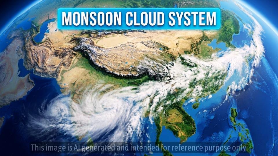
Have you heard about the massive cloud formation stretching from India all the way to South Korea. It is quite a sight. A recent satellite image showing a nearly 10,000 kilometer long cloud band has captured attention all over the world. People are calling it a monster cloud, but there is a lot more to this story than just its scary size.
What Actually Is This Massive Cloud Band
This is perhaps the biggest misconception. It is not actually one single cloud floating across the continent. Instead, it is a continuous belt of rain bearing cloud systems that are all linked together by large scale atmospheric circulation. Imagine it like a relay race where one runner passes the baton to the next. In this case, various weather systems are working in harmony across Asia.
The Step by Step Formation Process
The formation of this system starts with the intense summer heating over Asia during the months of May, June, and July. The sun is positioned almost directly over the Northern Hemisphere, which causes the land to heat up much faster than the oceans. This extreme heat over northwestern India, Pakistan, and the Tibetan Plateau creates a vast low pressure region.
Nature always tries to find a balance, so moist air rushes towards this low pressure zone. This air picks up moisture from the Arabian Sea, the Bay of Bengal, and the Equatorial Indian Ocean. As the winds travel, they continuously absorb water vapor and the relative humidity increases. This triggers atmospheric instability and causes deep convective clouds to form.
Next comes the orographic lifting by the Himalayas. When these moisture laden winds hit the mountain barrier, they cannot cross easily. The air is forced upwards, the temperature drops, and the water vapor condenses. This results in heavy orographic rainfall. Finally, the circulation does not stop over India. Upper level winds continue to transport moisture towards Tibet, China, the Yellow Sea, and the Korean Peninsula, creating the long, continuous belt we see in satellite imagery.
Why Scientists Call It A Monsoon Convergence Zone
A Convergence Zone is simply an area where winds from different directions meet. When this moist air converges, it cannot move downwards. It is forced to rise vertically. As it rises, it cools, condensation occurs, and the clouds become thicker. This leads to heavy monsoon rainfall. The stronger the convergence, the heavier the rain will be.
Does This Guarantee A Bumper Monsoon
While a large cloud band is a positive indicator, it is not a guarantee of a perfect season. Seasonal rainfall depends on many interacting climate drivers. Factors like the El Niño Southern Oscillation and the Indian Ocean Dipole play a massive role. El Niño generally weakens the Indian monsoon, while La Niña often strengthens it. Similarly, a positive Indian Ocean Dipole can enhance rainfall, while a negative one might suppress it.
The Benefits and Risks
If this active phase continues, it brings plenty of benefits for agriculture, such as better Kharif sowing, improved soil moisture, and higher crop productivity. It also fills reservoirs faster, which helps with drinking water availability and groundwater recharge. It even boosts hydropower generation.
However, we must also acknowledge the potential risks. Very active monsoon conditions increase the threat of flash floods, urban flooding, and riverine floods. It can lead to landslides in Himalayan states, soil erosion, crop waterlogging, and significant infrastructure damage. It is a reminder that while the monsoon is a lifeline, it is also a powerful force of nature.
A Social Message of Connection
When we look at this 10,000 kilometer long system, it shows us how deeply connected we all are. The water that evaporates from the ocean near one country travels thousands of kilometers to bring life, and sometimes challenge, to another. We share the same atmosphere and the same weather patterns. Let us treat each other and our shared planet with the same care and respect that keeps our world in balance.
Standard Legal Disclaimer: This article is for informational and educational purposes only. Weather patterns are complex and subject to rapid change. Always refer to official meteorological department updates and local government warnings for accurate, real time information regarding weather events and safety precautions in your area.








Leave a Reply